LecceMeteo is the weather portal I manage for Lecce and Salento. It follows the same philosophy as MeteoPomarico : providing clear local weather data and combining it with forecasts, alerts, satellite imagery and useful information for the territory.
The project is built around a weather station installed in Lecce, collecting real local data such as temperature, humidity, pressure and rain. Wind is not measured directly by the local station: for that part, as well as for forecasts, UV index, air quality, pollen and marine data, the portal integrates external sources and presents them consistently within the dashboard.
The goal is to provide a practical reading of Salento’s weather: not only “what will the weather be like”, but also what is happening now, what the coast conditions are, where the sea is more favourable and whether there are alerts to keep in mind.
What it offers
LecceMeteo lets users check current conditions through a dashboard designed for both desktop and mobile. The website shows local observations, recent trends and a set of additional information useful both for people living in Lecce and for those moving along the Salento coastline.
Main features include:
- Local weather data from the Lecce station
- Historical charts over 24 hours, 7 days and 30 days
- Station records for temperature, humidity and pressure
- Daily and hourly forecasts
- Air quality, pollen, sunrise, sunset and moon phase
- Weather alerts from the Italian Civil Protection
- EUMETSAT satellite imagery processed into a 24-hour animation
- Marine section with wind, waves, sea temperature and sea state
- Interactive map of coastal conditions
- Dedicated APIs for the website and external integrations
Sea and Salento beaches
The most distinctive part of the portal is the beach section. LecceMeteo monitors 35 locations across Salento, distributed between the Adriatic coast, the Ionian coast and the area around Santa Maria di Leuca.
For each area, the system processes wind, waves, sea temperature and sea state, providing an immediate reading of the day. Users can understand which coast is more sheltered, where the sea is calmer, which beaches have better conditions and whether there is anything to consider before heading out.
It is a feature designed for the territory: for people living in Salento, for those going to the beach after work, for anyone choosing between the Adriatic and Ionian coasts, and for tourists looking for a simple answer to a very practical question: where should I go today?
Satellite and weather data
In addition to station data and forecasts, LecceMeteo includes a dedicated satellite imagery pipeline. EUMETSAT images are acquired, processed and turned into a 24-hour animation using FFmpeg.
This makes it possible to observe the evolution of cloud systems and weather patterns over southern Italy and the Mediterranean, adding a broader view to the local station data.
Architecture and automation
From a technical point of view, LecceMeteo is a PHP platform with a database, JSON APIs, caching, rate limiting, cron jobs and automated monitoring processes. The system collects station data, integrates external sources, updates caches and publishes information through dedicated endpoints.
As with MeteoPomarico, an important part of the project is social media automation. The system automatically generates posts for Instagram and Facebook based on live weather data: images, stories and visual content are rendered with ImageMagick and published through the Meta Graph API.
During the beach season, the pipeline also generates content dedicated to sea and beach conditions in Salento. Marine reels are organised by geographical areas: Northern Adriatic, Southern Adriatic, Southern Ionian and Northern Ionian. This turns data about wind, waves and sea state into visual updates designed to be checked quickly on social media as well.
The processes include logs, deduplication, temporary file cleanup, error handling and Telegram notifications. The goal is to keep the website and social channels updated without turning every publication into a manual task.
Why I built it
LecceMeteo was born as a natural evolution of MeteoPomarico, but with its own identity. Living in Lecce, I wanted to bring the same idea of local weather here too: clear, up-to-date and useful data, not just generic forecasts.
Salento, however, has something extra: its everyday relationship with the sea. Within a short distance, you can move from the Adriatic to the Ionian coast, and choosing the right side can completely change the day. For this reason, I wanted to build a portal that does more than show temperature and forecasts: it helps people understand where it makes sense to go, what sea conditions to expect and what is happening along the coast.
LecceMeteo brings together my passion for meteorology, the experience gained with MeteoPomarico and the desire to create a useful tool for the territory where I live. It is designed for people living in Lecce and Salento, for those moving between the two coasts and for anyone looking for weather information that is more concrete, local and readable.
Connected app
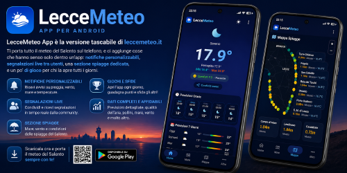
The project also has a dedicated Android app, developed as a mobile extension of the portal. The app will be described separately, because it has its own features and logic.
Links
- Website: leccemeteo.it
- Facebook: LecceMeteo
- Instagram: @leccemeteo

Use the share button below if you liked it.
Your click is my virtual high-five.